Can Drones Fill the Gap?
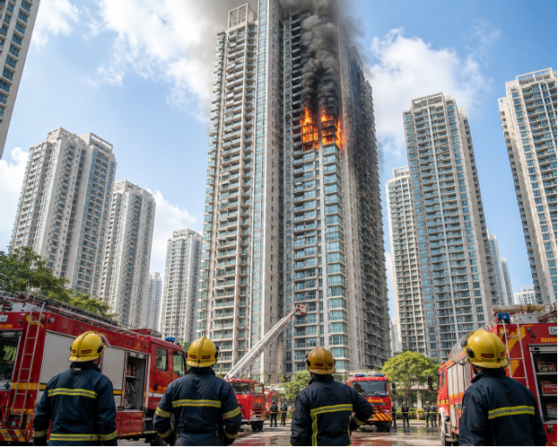
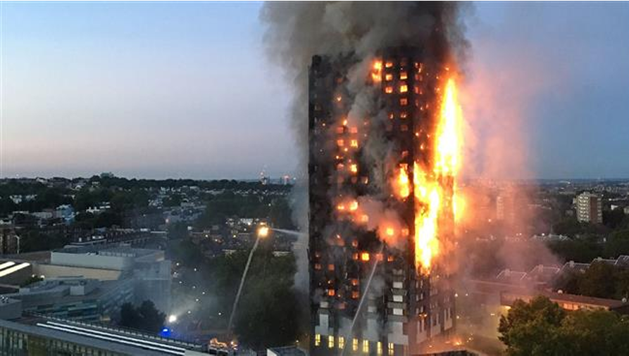
Every minute counts in a skyscraper fire. But India’s firefighters are still working with ladders that barely touch the 6th floor. What happens next?
“Imagine you’re stuck on the 28th floor. Smoke is seeping under the door. You call 101 and the fire engine’s ladder only reaches floor 9.”
This isn’t a hypothetical. This is the very real situation millions of Indians face every single day as they live, work, and study in soaring towers across Mumbai, Delhi, Hyderabad, Kolkata, Bengaluru, and Pune. India is on a skyscraper spree. But its emergency response system ladders, water cannons, and firefighters hasn’t kept up. The gap between how high we’re building and how high we can rescue people is not just a policy failure. It’s a ticking clock above millions of heads. Just How High Are We Building? India added more than 120 million square feet of commercial real estate in 2024 alone. Cities like Mumbai have over 1,600 buildings taller than 70 meters. Hyderabad’s skyline has doubled in a decade. Noida, Gurugram, and Pune are racing to keep up.
| 1,600+ Buildings above 70m in Mumbai alone | 9th Floor — max height most fire ladders reach |
| 40% India’s fire stations are understaffed vs. global norms | 3 min Survival window in a high-rise fire without rescue |
The problem is stark: most Indian fire departments use hydraulic ladder trucks that top out at 30–42 meters (roughly 9–12 floors). For anything above that? There is no standardized national plan.
REAL INCIDENTS
When the System Broke Down
These aren’t just statistics. People have paid the price. Here are incidents that shook India:
- Kamala Mills Fire, Mumbai (2017)
- Takshashila Arcade, Surat (2019)
- Delhi Hospital Fire (2024)
- 12th Floor Noida Apartment (2026)
In each of these cases, the building was taller than the rescue. The law allowed construction. The rescue technology didn’t catch up.
The Headlines We’ve Been Seeing
Over the past few years, a troubling pattern has repeatedly appeared across the front pages of India’s leading newspapers. Whether it’s a residential tower in Mumbai, a commercial complex in Delhi, a high-rise apartment in Kolkata, or a newly developed housing society in Noida, the headlines often tell a similar story: a fire breaks out on an upper floor, thick smoke engulfs the building, residents become trapped, and rescue teams race against time to prevent a tragedy.
These incidents are not isolated. They are becoming increasingly common as Indian cities continue to build upward. As skylines grow taller, so do the challenges faced by emergency responders.
The reality is that firefighters often reach the scene within minutes. The bigger challenge begins after they arrive.
From the ground, it is nearly impossible to understand the full scale of a high-rise emergency. Commanders must quickly determine critical information: Where exactly is the fire spreading? How many floors have already been affected? Are residents trapped on balconies or rooftops? Has smoke entered ventilation shafts and stairwells? Are evacuation routes still safe? Can rescue personnel safely access the upper floors?
These are not simple questions. Yet every one of them demands an immediate answer.
In many cases, emergency teams are forced to make life-saving decisions with limited visibility and incomplete information. Dense smoke can hide the true extent of a fire. The height of a building can restrict visual assessment. Critical developments may be taking place on floors that cannot be seen from street level.
And in an emergency, uncertainty is dangerous.
Because every minute spent trying to understand the situation is a minute not spent controlling the f ire, rescuing occupants, or preventing further damage. In high-rise incidents, the difference between a successful rescue operation and a major disaster often comes down to one thing: having the right information at the right time.
The Problem Nobody Talks About: Visibility
When a fire breaks out in a high-rise building, most people assume the biggest challenge is extinguishing the flames. Images of powerful water jets, fire engines, and firefighters climbing stairwells often dominate our understanding of emergency response. But ask any experienced firefighter, and they will tell you that one of the biggest challenges is not the fire itself—it’s the lack of visibility.
In a high-rise emergency, information becomes as important as water. Before rescue teams can save lives, they need to understand exactly what is happening inside and around the building. The problem is that gaining that understanding is often incredibly difficult. From the ground, emergency responders may be able to see flames emerging from a few windows and thick smoke rising into the sky, but the full picture remains hidden. They cannot easily determine whether the fire has spread to adjacent floors, whether residents are trapped on balconies, whether smoke has entered evacuation routes, or whether structural damage is beginning to compromise parts of the building.
Imagine standing outside a 40-storey residential tower during an active fire. Hundreds of people may still be inside. Families could be waiting for help on upper floors. Smoke might be spreading through corridors and stairwells faster than anyone realizes. Yet from street level, much of this information remains invisible. Emergency commanders are forced to make critical decisions based on limited observations, radio communications, and reports from teams operating inside the building. In a situation where every second matters, uncertainty becomes one of the greatest obstacles.
This lack of visibility creates a dangerous gap between what is happening and what emergency teams know is happening. And in disaster response, even a few minutes spent gathering information can have serious consequences. Delays in identifying trapped occupants, locating the most affected areas, or understanding the direction of fire spread can significantly impact rescue operations. The challenge is not simply reaching the fire—it is understanding the emergency quickly enough to respond effectively.
Enter the Drone: The Eye in the Sky
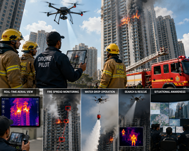
Now imagine the same situation with a different approach. The emergency call comes in, firefighters arrive on the scene, and alongside them a drone response team is deployed. Within moments, a drone takes off and begins flying around the building. What previously took precious minutes to assess can now be understood almost instantly.
As the drone gains altitude, it transmits a live aerial feed directly to emergency command personnel. Suddenly, responders are no longer relying solely on ground-level observations. They can see the entire building from multiple angles. They can identify where flames are spreading, which floors are most affected, and whether people are stranded on balconies or rooftops awaiting rescue. Areas hidden by smoke or obstructed from street view become visible through advanced imaging systems.
Modern emergency-response drones equipped with thermal cameras can provide even more valuable information. Through dense smoke, they can detect heat signatures, identify hidden hotspots, and help locate trapped occupants who may not be visible to the naked eye. This real-time intelligence allows emergency teams to prioritize rescue efforts, allocate resources more efficiently, and make faster, better-informed decisions.
The transformation is remarkable. Instead of operating with limited visibility and uncertainty, incident commanders gain a comprehensive view of the situation within minutes. Rescue teams know where help is needed most. Firefighters can focus on critical areas. Resources can be deployed strategically rather than reactively.
In that moment, the drone becomes far more than a flying machine. It becomes the eyes of the emergency response team. It provides the information needed to act quickly, safely, and effectively. As India’s cities continue to grow vertically and emergency situations become more complex, drones have the potential to become one of the most valuable tools in modern disaster management helping responders see what was once impossible to see and making every second count when lives are on the line.
Drones Are Already Changing Emergency Response Worldwide
Around the world, emergency agencies are rapidly integrating drone technology into disaster management strategies.
Modern drones can:
Detect Heat Through Smoke
Thermal imaging cameras allow operators to identify hotspots that are invisible to the human eye.
This helps locate:
- Hidden fire sources
- Trapped victims
- Dangerous temperature zones
Reach Dangerous Areas
Before sending personnel into hazardous environments, drones can assess risks from above.
Provide Real-Time Intelligence
Instead of relying on fragmented information, commanders receive a live overview of the entire incident.
Support Search and Rescue Operations
Drones can scan rooftops, balconies, flooded regions, collapsed structures, and inaccessible locations far faster than traditional methods.
The Results?
- Faster Decision
- Safe Rescue Operation
- Better Coordination
And Fires Are Just the Beginning
When we talk about drones in disaster management, it is easy to focus on high-rise fires. After all, the image of a drone flying through smoke-filled skies above a burning building is powerful. But the reality is that fires are only one part of a much larger story.
India is one of the world’s most disaster-prone countries. Every year, millions of people are affected by floods, cyclones, landslides, earthquakes, and extreme weather events. In many of these situations, the biggest challenge isn’t reaching people—it’s knowing where help is needed first.
This is where drones are rapidly becoming an essential tool for modern disaster response.
Floods: When Entire Communities Disappear Underwater
Every monsoon season, states such as Assam, Bihar, West Bengal, and Kerala face devastating floods that can cut off villages, damage infrastructure, and leave thousands stranded.
For rescue teams, one of the biggest problems is visibility. Roads disappear underwater, communication networks fail, and entire communities become inaccessible.
In such situations, drones can:
• Identify stranded families and individuals
• Map flood-affected regions in real time
• Monitor water levels and movement
• Guide rescue boats to safe routes
• Deliver emergency supplies to isolated areas
• Assess damage faster than traditional ground surveys
Instead of waiting hours or even days for information, authorities can get a complete aerial picture within minutes.
Earthquakes: Finding Survivors Faster
Earthquakes create some of the most challenging rescue environments imaginable. Collapsed buildings, unstable structures, debris-filled streets, and limited visibility make search and-rescue operations extremely difficult.
In these situations, drones can:
• Assess structural damage quickly
• Identify safe access points for rescue teams
• Search large areas efficiently
• Detect heat signatures using thermal imaging
• Help locate survivors trapped under debris
When every minute matters, aerial intelligence can significantly improve rescue efforts.
One Technology. Multiple Life-Saving Applications.
Whether it is a flooded village in Assam, a cyclone-hit coastline in Odisha, a landslide in Uttarakhand, or a high-rise fire in Mumbai, the challenge remains the same:
Emergency responders need information before they can take action.
Drones provide that information faster than ever before.
They help authorities see what cannot be seen from the ground, understand situations in real time, and make informed decisions when lives are at stake.
And as climate change increases the frequency and intensity of natural disasters, the importance of drone technology in India’s disaster-management ecosystem will only continue to grow.
The future of disaster response isn’t just on the ground anymore. It’s in the sky.
Why India Needs More Than Drones—It Needs Trained Drone Pilots
The Technology Is Ready. The Real Question Is: Who Will Fly It?
As discussions around drone technology continue to grow, one important fact is often overlooked: drones do not save lives on their own.
Behind every successful disaster-response mission, every emergency assessment, and every lifesaving aerial operation is a trained professional making critical decisions in real time.
A drone is only as effective as the person operating it.
Imagine a major flood has submerged an entire village. A drone is deployed to locate stranded families. Or picture a high-rise fire where emergency teams need thermal imagery to identify trapped residents. In both cases, the technology may be available—but without a skilled operator, even the most advanced drone becomes just another machine.
This is why India’s growing drone ecosystem requires more than cutting-edge technology. It requires highly trained drone pilots who can transform aerial data into meaningful action.
What Makes a Professional Drone Pilot Different?
Modern drone operations involve far more than simply taking off and landing.
A professional drone pilot must be able to assess situations, make quick decisions, and operate safely under pressure.
Key skills include:
Emergency Response Operations
• Understanding disaster-management protocols
• Supporting rescue and relief teams
• Operating in high-pressure environments
• Coordinating with emergency agencies
Airspace Safety & Regulations
• Following DGCA guidelines
• Managing flight permissions
• Ensuring safe operations near populated areas
• Avoiding risks to people and infrastructure
Mission Planning
• Evaluating weather conditions
• Selecting optimal flight routes
• Managing battery and operational limits
• Preparing contingency plans
Thermal Imaging & Advanced Sensors
• Detecting heat signatures during fires
• Identifying hidden hotspots
• Locating trapped individuals
• Supporting search-and-rescue missions
Mapping & Survey Technology
• Creating aerial maps
• Generating 3D models
• Conducting infrastructure inspections
• Supporting disaster-impact assessments
Situational Awareness
• Interpreting real-time aerial data
• Identifying emerging risks
• Making informed operational decisions
• Communicating critical information to response teams
In short, the drone pilot of the future will not simply fly a drone—they will manage information, support decision-making, and assist in solving complex real-world problems.